
Gas Mapping LiDAR® in Australia
Methane detection built for Australia’s toughest terrain
Aerial laser technology that can help operators across production, pipeline, and LNG identify and address methane emissions — without putting crews into remote or hazardous locations.
Start the Conversation
90%+
Probability of detections at ≥1 kg/hr
~2m
GPS-precise emitter location accuracy
12+
Peer-reviewed independent validation studies
30+
Patents protecting GML technology
Why Australian Operators Choose Bridger
The Australian energy landscape has specific demands. Bridger’s aerial approach is designed to meet them
Protect your people first
Australia’s production and pipeline assets often span vast, isolated desert terrain. Bridger’s aerial approach can help teams identify and prioritize issues before anyone is sent into the field — so every deployment is targeted, not exploratory.
Coverage at Australian scale
Hundreds of sites or hundreds of kilometres of pipeline covered in a single day. No ground infrastructure to install. No hardware on each site. Share your GIS data with Bridger’s team, and we handle the rest — from flight logistics to full data delivery.
Data you can defend
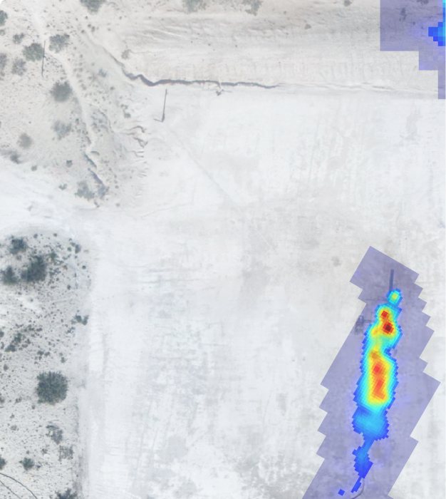
Every scan delivers quantified emission rates, gas plume imagery, and equipment-level GPS coordinates. Audit-ready from day one. Validated by more than a dozen independent peer-reviewed studies — the transparency that serious programs require.
See how Woodside is taking action on methane with Bridger Photonics
The Technology
How Gas Mapping LiDAR® works
Laser-based aerial scanning that detects, locates, and quantifies methane — remotely, precisely, and at scale.

01: You share your asset GIS data
You share your asset GIS data Simply provide the GIS coordinates of the assets you’d like scanned. Bridger designs tailored flight plans to ensure full coverage across your sites or pipeline corridors.

02: Aerial laser sensors scan your assets
GML sensors mounted on small aircraft emit laser light that is absorbed by methane molecules. The system detects, locates, and quantifies emissions continuously as the aircraft flies — no ground crew required.
03: 24-hour safety alert for large emitters
Any emission above your pre-set threshold triggers a same-day safety notification — so your team can respond to the highest-priority issues immediately.
04: Full Data Report within 2-3 Days
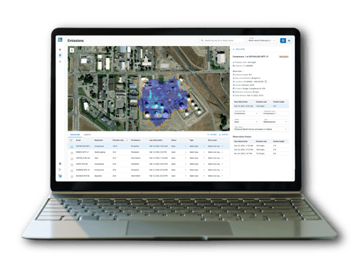
mission rates, equipment-level GPS locations, plume imagery, and aerial photography — delivered via Bridger Command in any format your team needs. Your field crews know exactly where to go.
-
90%+ Probability of detection ≥1 kg/hr
-
~2m Emitter location precision
-
24hr Safety alert turnaround
-
1–15 kg/hr Configurable sensitivity range
Wind & measurement accuracy: GML quantification is a direct function of wind speed. Independent studies show quantification uncertainty of ±31–68% near the sensitivity limit — a well-characterized range that supports transparent, defensible reporting.
What Bridger Can Help You Do
Reduce unnecessary field exposure
Aerial detection can reduce the need to send crews to remote sites for routine inspection. When your team does go to the field, they arrive knowing exactly what they’re looking for — and where. Fewer exploratory trips. Safer operations.
Find what ground-based methods miss
Bridger’s technology can help identify emissions that intermittent manual surveys may not catch — particularly at the scale and spread of Australian assets. Equipment-level source localization means your repair teams address root causes, not symptoms.
Support emissions reporting and commitments
GML data may support measurement-based reporting aligned to OGMP 2.0 Level 4 and Level 5. For operators working toward net-zero targets or navigating LNG buyer expectations, Bridger’s auditable data can help build a credible foundation.
Trusted by leading Australian energy companies
Bridger is already active in Australia — and the work is real.
Case Study
APA Group
“APA Group has partnered with Bridger Photonics to scan gas transmission pipelines and facilities across the country to accurately detect and measure methane emissions.”
Bridger’s data is supporting APA in taking targeted action to address operational methane emissions, consistent with APA’s 2030 methane reduction target and net-zero operational emissions goal by 2050.
Case Study
Woodside
Woodside is working with Bridger to support their journey toward OGMP 2.0 Gold Standard — among a growing list of global LNG and production operators choosing Bridger for defensible emissions measurement.
As one of Australia’s largest LNG operators, Woodside’s adoption reflects the growing demand for high-resolution, measurement-based methane data across the LNG sector.
Production
Pipeline
LNG
Well Pads & Processing Facilities
Rapidly survey production assets across large basins. Detect, locate, and prioritize emissions by rate — so maintenance effort goes where it matters most.
Gas Transmission & Gathering
Scan hundreds of kilometres per day. GML’s aerial approach is purpose-built for Australia’s long-distance, remote transmission networks — the kind of coverage that isn’t practical with ground-based methods.
Facilities & Export Terminals
LNG buyers and investors globally are placing growing importance on methane accountability. Bridger can help LNG operators build the measurement-based data programs that support credible reporting.
Frequently Asked Questions
-
How does Gas Mapping LiDAR actually measure methane?
GML sensors emit laser light at a wavelength that methane molecules absorb. As the aircraft flies over assets, the system measures how much light is absorbed; deriving a path-integrated concentration reading. This is combined with emission modeling to estimate a leak rate and GPS-locate the source.
-
Does wind affect accuracy?
Wind speed is a factor in quantification accuracy — and Bridger is transparent about this. Independent studies show uncertainty of ±31–68% near the detection limit, with performance improving as emission size increases above the sensitivity threshold. On-site wind data can further reduce uncertainty.
-
What detection sensitivity is used for Australian operations?
Bridger offers configurable sensitivity from 1–15 kg/hr with ≥90% probability of detection, for both production and transmission sectors. The right threshold depends on your assets and goals — Bridger works with each operator to calibrate the approach.
-
How long does a scan program take to set up?
After an initial Kickoff meeting to review your goals and GIS data, Bridger handles all flight planning and logistics. First safety alerts are delivered within 24 hours of a scan, with full reports in 2-3 business days.
-
Can the technology cover remote Australian assets?Yes — in fact, remote coverage is one of GML’s core strengths. The aerial approach covers hundreds of sites or hundreds of kilometres of pipeline per day, with no requirement for personnel or hardware in the field during the scan.
-
What data do we actually receive?
Each scan delivers emission rates, maximum path-integrated concentration, methane plume imagery, emitter GPS coordinates, intermittent/persistent designation, and aerial photography — Delivered via our emissions visualization web-platform, Bridger Command
