Skip to content

GML for Landfills

Precision methane emissions data for compliance, cost savings, and community trust.

Landfill operators work hard to manage methane, but monitoring methods available make it difficult. Bridger is here to help.

image 173

Trusted by Industry Leaders

Why Operators Choose Bridger

Bridger Photonics brings proven Gas Mapping LiDAR (GML) technology—used across the oil and gas sector—to landfills, giving operators measurement-based data they can stand behind.

Cost savings

Avoid unnecessary, multi-million-dollar remediation projects triggered by inflated model estimates. Scans take minutes to hours, not days.

Actionable operations

Pinpoint leaks to quickly remediate.

Stakeholder trust

Share clear, map-based visuals that demonstrate methane mitigation to regulators, investors, municipalities, and communities.

Key Advantages of GML for Landfills

BP Icon Helicopter size 120x120

Comprehensive coverage
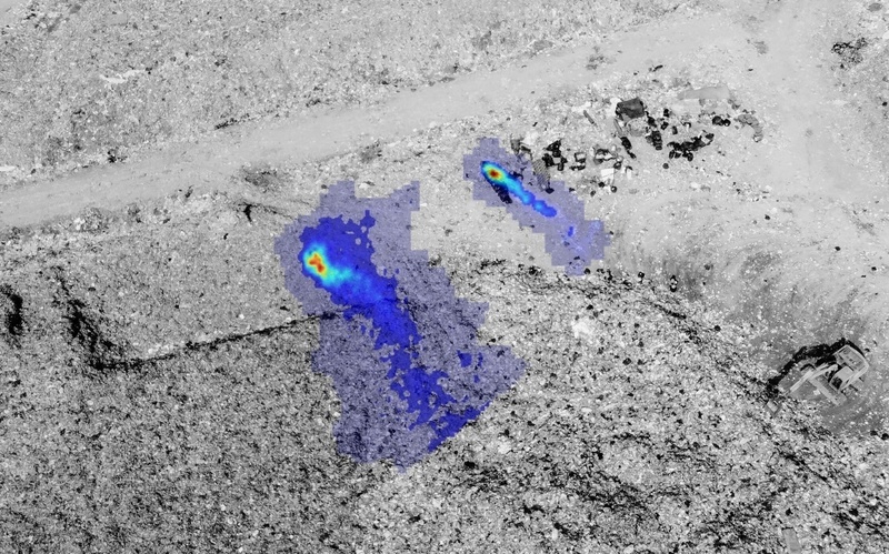
Scan 100% of landfill surfaces.

BP Icon Target size 120x120

Pinpoint accuracy

Localize emissions sources within ~2 meters for targeted fixes.

Mountain Summit

Confidence

Replace assumptions with measurement-based data that stands up to scrutiny.

BP Icon Money size 120x120

Cost control

Avoid inflated model-based estimates that trigger unnecessary projects.

BP Icon Outcome size 120x120

ESG proof

Share transparent, visual evidence of methane reductions with stakeholders.

Proven in the Field

In independent research at Yolo County Landfill in Davis California, Bridger’s GML demonstrated accurate whole-landfill methane measurement, outperforming both walkover and model-based approaches.

By combining full-site coverage with high precision, GML gives operators data they can trust for compliance, cost control, and public accountability.

Landfill Plume

Talk to a Landfill Expert

Let’s find out how GML can support your methane management goals.