Skip to content

OGMP 2.0, Simplified

The fastest, most accurate path to Gold Standard reporting.

untitled_design_54

Trusted By Industry Leaders

What Makes OGMP 2.0 So Hard?

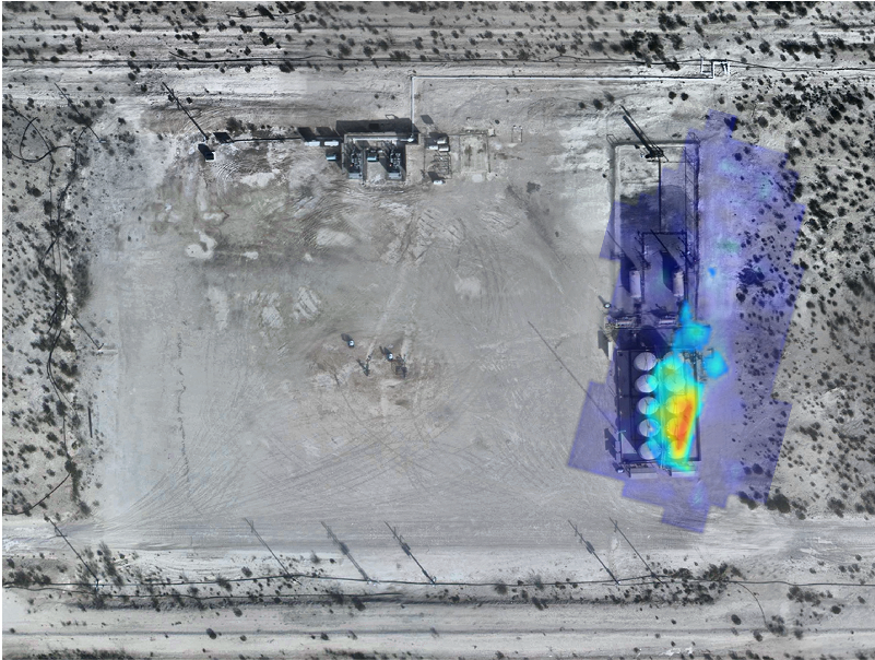
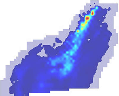
OGMP 2.0 sets the global standard for methane emissions reporting, requiring operators to move from estimates to measured emissions data.


Bridger Compliance for OGMP 2.0 delivers high-resolution aerial methane data that help operators meet OGMP Level 5 requirements for site-level measurement with source-level detail. Our approach allows operators to rapidly measure source- and site-level emissions, create defensible emissions inventories, and integrate verified data into OGMP reports.

point-cloud-overlay-background-15

Why Operators Choose Bridger for OGMP 2.0

We help upstream operators meet OGMP 2.0 requirements faster, more reliably, and with ease:

Level 5-ready measurement:

Site-level measurements with source-level localization meet the Gold Standard for reporting.

Defensible, science-based data:

Validated by third-party testing at CSU METEC, Carleton University EERL, and others.

Scalable coverage:

Our tech surveys hundreds of sites in a single campaign, including remote or hard-to-access assets.

Streamlined workflow:

From measurement to reporting, we integrate directly into OGMP compliance processes.

AdobeStock_1388150340-1

Site Level Measurement

We design a statistically representative site-sampling plan, then survey each site using our aerial Gas Mapping LiDAR (GML). The data is aggregated into accurate, OGMP-compliant site-level totals without any reliance on generic emissions factors.

Photo of oil field heavy saturated

Total Emissions Estimation

We quantify emissions at both source and facility scale, producing a complete inventory ready for OGMP reporting. This methodology supports full Level 5 compliance and aligns with Veritas protocols.

AdobeStock_1571182793

Fast, Defensible Results

Data is processed using validated methods, delivering a complete dataset you can stand behind in front of boards, regulators, and ESG stakeholders.

Challenge

Solution

High-precision, site-level emissions data to support inventory estimates
Aerial GML covers hundreds of sites per scan, reducing site visits and cost.
Level 5 requires site-level totals built from measured data.
Our total emissions estimation methodology ensures accurate, defensible quantification.
Tight OGMP timelines and operational demands.
A seamless workflow from planning to reporting keeps you compliant without disruption.

Challenge

  • Diverse assets spread far apart make traditional surveys costly and slow.
  • Level 5 requires site-level totals built from measured data.
  • Tight OGMP timelines and operational demands.

Solution

  • Aerial GML covers hundreds of sites per scan, reducing site visits and cost.
  • Our total emissions estimation methodology ensures accurate, defensible quantification.
  • A seamless workflow from planning to reporting keeps you compliant without disruption.

Basic

Measurement Package


Provides expert guidance for implementing Gas Mapping LiDAR® measurements for accurate source- and site-level methane detection.

Premium

Measurement Package


Adds statistically sound site-sampling methodologies to ensure representative Level 5 emissions measurement.

Platinum

Measurement Package


Offers total emissions estimation, including structured site-level analysis to support OGMP Level 5 reporting.

Validated Performance You Can Stand Behind

Our Gas Mapping LiDAR® is verified through independent controlled release studies. It consistently detects methane at ~1 kg/hr with 90% probability of detection. This proven accuracy ensures your OGMP reports are both compliant and defensible.

Talk to a GML Expert

Let’s find out how GML can support your OGMP-related goals.

 Frequently Asked Questions

  • What does OGMP Level 5 require?

    Level 5 reporting requires a variety of things, including site-level measurement based on measured data, with source-level detail for transparency.

  • How fast can Bridger cover assets?

    Hundreds of sites per day, including remote or hard-to-access locations.

  • How does Bridger’s Gas Mapping LiDAR compare to ground-based surveys for OGMP 2.0?

    Bridger’s aerial scans cover hundreds of sites per day and detect smaller leaks at higher probability of detection than most handheld methods, making them faster, more scalable, and often more cost-effective for Level 5 compliance.

  • Can Bridger’s data be used for both OGMP 2.0 and Veritas reporting?

    Yes. Our measurement and estimation methodologies align with both OGMP 2.0 Level 5 requirements and Veritas protocols, allowing operators to meet multiple reporting frameworks with the same dataset.